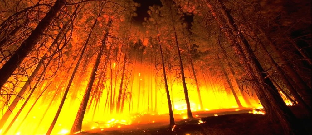
In the summer of 2012, the lightning-sparked Dahl Fire in central Montana scorched more than 22,000 acres, leading to the destruction of 74 homes and 149 other buildings. Sadly, residents of Montana are all too familiar with tragedies like the Dahl Fire, with wildfires roaring across thousands of acres every year.
New data brings the ever-present danger of Montana wildfires into sharper focus.
A LawnStarter analysis of data from CoreLogic, a provider of real estate data, shows Montana faces the biggest risk of wildfire damage to single-family homes among 13 wildfire-prone states in the West and Southwest. Those 13 states form a geographic zone with the highest overall wildfire risk in the U.S. LawnStarter’s calculations put Montana’s wildfire risk at more than 49 homes per 1,000 residents.
By sheer volume, California and Texas lead CoreLogic’s list of the 13 states in the West and Southwest that have the most single-family homes at “extreme” or “high” risk of damage caused by wildfires. In California, 645,445 homes fall into the “extreme” or “high” risk category, with Texas coming in second place at 532,317.
Those numbers are to be expected, given that California and Texas are the country’s two most populous states. So we decided to pair the CoreLogic risk data with Census Bureau population data to arrive at a per-capita look at the risk of wildfire damage to homes. Relying on that formula, Montana climbed to the top of our list.
A Vulnerable State
While Montana has far fewer homes in the “extreme” and “high” risk columns — 50,981 — its considerably smaller population (1,032,949) means Big Sky Country’s per-capita risk rises much higher than the per-capita risk for California (nearly 16.5 homes per 1,000 residents) or Texas (nearly 19.4 homes per 1,000 residents).
“Wildland and rangeland fires are hazards that impact Montana every year. In mild fire seasons, there may be relatively small timber and crop … losses. In extreme years, there can be resource devastation, habitat destruction, structure losses and deaths,” according to a 2013 report issued by the State of Montana. “All of Montana is vulnerable in one form or another to wildland and rangeland fires.”
In fact, wildfire has been cited as the No. 1 natural hazard in Montana.
A 2004 study by the U.S. Bureau of Land Management found that nearly 39 percent of 622 communities in Montana were in the “extreme” or “high” risk category for wildfires. The risk is especially prominent in wildland-urban interface areas, where homes encroach on wildfire-prone lands.
Close to Home
The State of Montana report cautions that when people build or buy homes in high-hazard fire areas, “their homes are potential fuel.” Among the factors increasing the fire wildfire risk to people and property are inadequate water supplies, poorly planned subdivisions and untreated roofs made of wood, the report says.
“Wildfire used to be something you could see from the road or read about in the newspaper. Now [the fires] are getting close to home,” Derek Yeager, fire management officer for Montana’s Southern Lands Office, told the Billings Gazette.
He added: “A lot of land in Montana is just not resilient, and it’s not getting any more resistant to fire.”
Ranking of Riskiest States
With Montana in the No. 1 position, here’s our per-capita ranking of the “extreme” or “high” fire risk for single-family homes in the 13 states highlighted by CoreLogic.
1. Montana
2015 population: 1,032,949
Number of homes in “extreme” or “high” risk fire category: 50,981
Per-capita risk: 49.35 homes per 1,000 residents
2. Idaho
2015 population: 1,654,930
Number of homes in “extreme” or “high” risk fire category: 67,877
Per-capita risk: 41.02 homes per 1,000 residents
3. Colorado
2015 population: 5,456,574
Number of homes in “extreme” or “high” risk fire category: 196,601
Per-capita risk: 35.85 homes per 1,000 residents
4. Oregon
2015 population: 4,028,977
Number of homes in “extreme” or “high” risk fire category: 130,674
Per-capita risk: 32.43 homes per 1,000 residents
5. New Mexico
2015 population: 2,085,109
Number of homes in “extreme” or “high” risk fire category: 63,229
Per-capita risk: 30.32 homes per 1,000 residents
6. Texas
2015 population: 27,469,114
Number of homes in “extreme” or “high” risk fire category: 532,317
Per-capita risk: 19.38 homes per 1,000 residents
7. California
2015 population: 39,144,818
Number of homes in “extreme” or “high” risk fire category: 645,445
Per-capita risk: 16.49 homes per 1,000 residents
8. Wyoming
2015 population: 586,107
Number of homes in “extreme” or “high” risk fire category: 7,067
Per-capita risk: 12.06 homes per 1,000 residents
9. Arizona
2015 population: 6,828,065
Number of homes in “extreme” or “high” risk fire category: 55,664
Per-capita risk: 8.15 homes per 1,000 residents
10. Utah
2015 population: 2,995,919
Number of homes in “extreme” or “high” risk fire category: 16,860
Per-capita risk: 5.63 homes per 1,000 residents
11. Nevada
2015 population: 2,890,845
Number of homes in “extreme” or “high” risk fire category: 13,881
Per-capita risk: 4.80 homes per 1,000 residents
12. Washington
2015 population: 7,170,351
Number of homes in “extreme” or “high” risk fire category: 32,595
Per-capita risk: 4.55 homes per 1,000 residents
13. Oklahoma
2015 population: 3,911,338
Number of homes in “extreme” or “high” risk fire category: 534
Per-capita risk: 0.14 homes per 1,000 residents
Top photo: Montana Governor’s Office of Community Service

![8 Best Shovels for Gardening of 2025 [Reviews]](https://www.lawnstarter.com/blog/wp-content/uploads/2021/08/Best-Shovels-for-Gardening-150x150.jpg)


